“Every mountain top is within reach if you just keep climbing.” – Barry Finlay
Mount Apo, dubbed as the “King of Philippine Peaks”, is the country’s highest mountain peak with an elevation of 10,311 feet or 3,144 meters above sea level. It is also one of the Philippines’and Southeast Asia’s much sought after climbing destination.

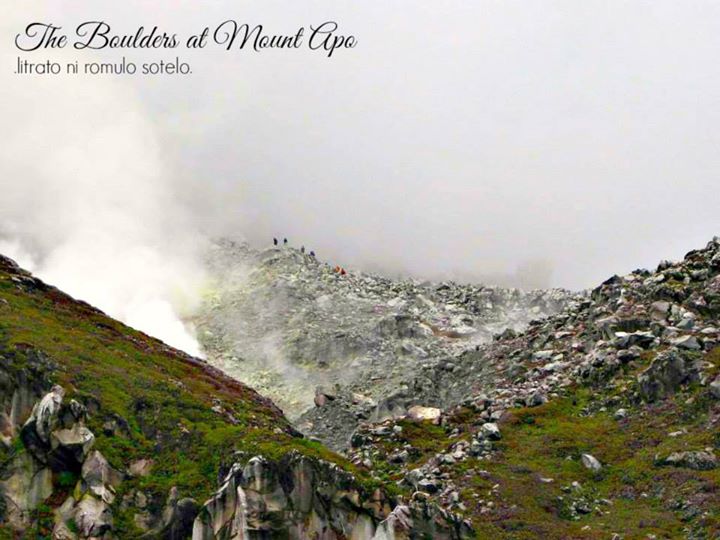
Apo means “ancestor” or “grandfather” or “elder”. Mount Apo , a sacred land among locals, is a large solfataric (a volcanic area that gives off sulfurous gases and steam), potentially-active stratovolcano (conical volcano built up by many layers (strata) of hardened lava, tephra, pumice, and volcanic ash). The date of its most recent eruption is unknown, and none are verified in historical times.

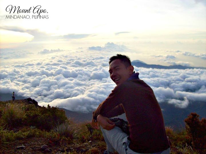
Mount Apo, looms over the immense stretch of the southern tip of Mindanao island, adjoins over the mountainous edges of Davao City. It provides a picture-perfect view attributed to its diverse landscape ranging from volcanic formations, boulders/rockscapes, and the rich virgin forest lands of Davao City, Davao del Sur and North Cotabato. The peak features a flat area with a 500-meter wide volcanic crater containing a small crater lake. The base of the mountain covers roughly about 72,796 hectares of mountain ranges that extend from Davao City, the provinces of Davao del Sur, Northern Cotabato, Bukidnon, Agusan del Sur, and Misamis Oriental.

When I accidentally started climbing (wayback 2004), I never pictured myself getting hooked with it. Never did I thought I would consider climbing Mt. Apo. But as I get to see and experience more mountains, the thought of a Mt. Apo climb slowly came into senses. It eventually became a predestined dream to chase. I guess it’s true that every Filipino mountain-enthusiast’s dream is to scale the Philippines’highest. And so in 2008, this vision was put into fruition.

How to get to Mount Apo
Davao is well connected to both Manila and Cebu City, the two busiest international airports in the Philippines, and several local low-cost carrier with new and modern fleet, offer cheap daily flights from both Manila and Cebu starting at less than 2000 pesos (one-way). I flied from Cebu City and paid 2500 pesos (one-way), and back to Cebu City for 1800 pesos only (one-way).
One can either stay a night in Davao City or go directly to Santa Cruz (45 km southwest of Davao), where a permit and guide/porter for Mount Apo must be arranged. After arriving Davao International Airport, try to avoid the taxi-touts at the entrance/exit who will try to charge 1500 pesos for a ride to Santa Cruz. Walk instead 50 metres from the terminal, where the white or yellow metred-taxis are. Here you can easily negotiate a price of 600-700 pesos. If you are on a really tight budget it will be even cheaper to commute like described below (total 207 pesos):
1. After arriving at Davao International Airport, ride a taxi to Ecoland Transport Terminal (travel time 20 minutes – 150 pesos)
2. At Ecoland Terminal, look for south-bound buses such as yellow bus, weena bus, ACFB or Metro Shuttle and ask the driver or the conductor that you will be dropped off at Santa Cruz Terminal (travel time 45 minutes to 1 hour – 43 pesos).
3. At Santa Cruz Terminal, take a motorcycle or tricycle taxi to the municipal hall, Tourism Office (travel time 5 minutes – 14 pesos)
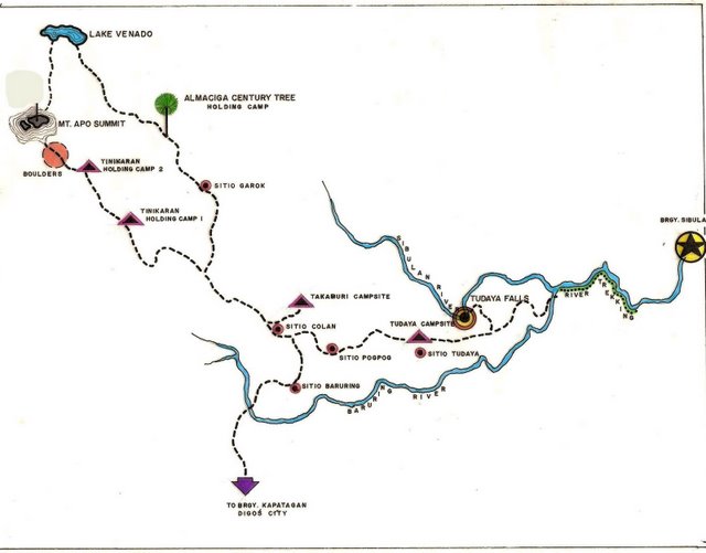
To get from Santa Cruz to the trailhead in Baroreng you can hire a jeep for 800 pesos or commute. The latter would be cheaper, 3 persons would cost 400+ pesos, but the time-frame would be more uncertain. While a jeep will take 1-1.5 hours to the trailhead in Baruring, commuting will take at least 2-3 hours depending on availability/departure of share-taxis, motorcycle taxis etc. First you need a bus from Santa Cruz to Digos, then a shared van/taxi from Digos to Kapatagan, and finally a motorcycle-taxi from Kapatagan to Baruring. (Excerpts from summitpost.org)
Some Things to Consider:
You need a permit for this mountain, and guide/porter is mandatory. At the Tourism Office in Santa Cruz ask for Julius Paner. You better contact him in advance, at least a couple of days before you arrive Davao.
His mobile: 09208567991 (replace the leading zero with +63 if you are calling outside of the Philippines)
His e-mail: trekjulpanz@hotmail.com
The fees are:
500 pesos in registration/trekking fee
500 pesos in exit-fee (only if exit-point differ from entry-point)
500 pesos per day for a guide (mandatory)
300 pesos per day for a porter (mandatory)
Other requirements (which to me is really too much and the things that I personally did not like prior to the climb) include a letter of intent, an application form, 1×1 picture, medical certificate, waiver, briefing, certificate of briefing, etc. The papers go through the following offices: OCEEM, the city mayor, and the CTO.

Sample Itinerary:
| Day 1 | |
| 03:00 AM | Registration |
| 03:30 AM | ETD Davao to Kapatagan. Breakfast along the way. |
| 08:00 AM | ETA Kapatagan. Jump off point. Start trek |
| 05:00 PM | ETA Camp Godi-Godi. Set Camp |
| 06:00 PM | Prepare Dinner |
| 07:00 PM | Dinner. Lights out. |
| Day 2 | |
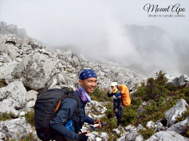
| 07:00 AM | Start Assault to Peak. Pass by boulders. |
| 12:00 PM | Boulders. Picture Taking. Lunch. Dead lake. |
| 03:00 PM | ETA Summit of Davao peak. |
| 04:30 PM | ETA Camp site. Set up camp. Dinner. |
| Day 3 | |
| 04:30 AM | Start Summit Assault for the Sunrise. Explore. |
| 08:00 AM | Breakfast. Break camp and start descent. |
| 05:00 PM | ETA Jump off point Kapatagan. Clean up. |
| 06:00 PM | ETD for Davao City |
| 10:00 PM | ETA in Davao City |

Things To Bring:
A good pair of trekking shoes
Sun and Rain Protection (Sun Block, rain coat, shades, cap etc.)
Water: # of days x 2 Liters
Trail food (snacks)
Clothes for the whole hike
Toiletries
Sleeping Bag/Blanket
Tent
Utensils
Headlamp / Flashlight
Raincoat / Umbrella
Trekking Pole
Slippers
Personal Medications
True enough Mount Apo is a significant climb, especially for individuals who are in search for adrenaline – inducing experiences . Its vista truly offers an adventure of a lifetime.
You can also check out (and hit the like button) my FB Page: https://www.facebook.com/roamulofied
Instagram: roamulofied

the clouds look really exquisite I’m starting to think they’re fake. but of course they aren’t. breathtaking.
LikeLike
Thank you sir for the appreciation.
LikeLiked by 1 person
you’re always welcome. But, really, I can only imagine how breathtaking is the view in person.
LikeLiked by 1 person
Great blog and fantastic photos. I’ve been to the Philippines many times (my wife is Filipina), but always struggle to get out of Manila. I’ve only been to Boracay and El Nido (El Nido was amazing). Anyway I must add this to my bucket list. Thanks for posting and safe travels.
LikeLike
wow thank you for your very nice words sir. I am glad you were amazed with El Nido. Welcome sir and happy and safe travels too! cheers!
LikeLiked by 1 person
The more I wander through your blog, the more I love it 🙂 Awesome job here!!!
LikeLiked by 2 people
Wow, that is so sweet of you to say my friend. Thank you.
LikeLiked by 1 person
[…] https://roamulofied.wordpress.com/2015/04/15/mount-apo-king-of-philippine-peaks/ […]
LikeLiked by 1 person
That is definitely included in my itinerary when I go to the PH next month!
LikeLiked by 2 people
Hope you enjoy and have fun sir. Cheers!
LikeLiked by 1 person
Reblogged this on penpowersong.
LikeLike
[…] https://roamulofied.wordpress.com/2015/04/15/mount-apo-king-of-philippine-peaks/ […]
LikeLiked by 1 person
[…] Photo Credit: https://roamulofied.wordpress.com/2015/04/15/mount-apo-king-of-philippine-peaks/ […]
LikeLiked by 1 person